Find a Singapore property district using the first two digits of a postal code—or enter the full six-digit code. Use the finder below, then browse the district table and map to put the location in context.
SINGAPORE DISTRICT FINDER
Find your property district
Enter the first two digits of a postal code, or the full six-digit code.
Leading zeros matter: enter 01, not 1. A full postal code is matched using its first two digits.
Browse all 28 districts
Use this reference to compare districts, postal sectors and general locations. Neighbourhood names can span more than one district.
| District | Postal sectors | General locations |
|---|---|---|
| D01 | 01, 02, 03, 04, 05, 06 | Raffles Place, Cecil, Marina, People’s Park |
| D02 | 07, 08 | Anson, Tanjong Pagar |
| D03 | 14, 15, 16 | Queenstown, Tiong Bahru |
| D04 | 09, 10 | Telok Blangah, Harbourfront |
| D05 | 11, 12, 13 | Pasir Panjang, Hong Leong Garden, Clementi New Town |
| D06 | 17 | High Street, Beach Road (part) |
| D07 | 18, 19 | Middle Road, Golden Mile |
| D08 | 20, 21 | Little India |
| D09 | 22, 23 | Orchard, Cairnhill, River Valley |
| D10 | 24, 25, 26, 27 | Ardmore, Bukit Timah, Holland Road, Tanglin |
| D11 | 28, 29, 30 | Watten Estate, Novena, Thomson |
| D12 | 31, 32, 33 | Balestier, Toa Payoh, Serangoon |
| D13 | 34, 35, 36, 37 | Macpherson, Braddell |
| D14 | 38, 39, 40, 41 | Geylang, Eunos |
| D15 | 42, 43, 44, 45 | Katong, Joo Chiat, Amber Road |
| D16 | 46, 47, 48 | Bedok, Upper East Coast, Eastwood, Kew Drive |
| D17 | 49, 50, 81 | Loyang, Changi |
| D18 | 51, 52 | Tampines, Pasir Ris |
| D19 | 53, 54, 55, 82 | Serangoon Garden, Hougang, Punggol |
| D20 | 56, 57 | Bishan, Ang Mo Kio |
| D21 | 58, 59 | Upper Bukit Timah, Clementi Park, Ulu Pandan |
| D22 | 60, 61, 62, 63, 64 | Jurong |
| D23 | 65, 66, 67, 68 | Hillview, Dairy Farm, Bukit Panjang, Choa Chu Kang |
| D24 | 69, 70, 71 | Lim Chu Kang, Tengah |
| D25 | 72, 73 | Kranji, Woodgrove |
| D26 | 77, 78 | Upper Thomson, Springleaf |
| D27 | 75, 76 | Yishun, Sembawang |
| D28 | 79, 80 | Seletar |
Reference: URA-hosted postal district list (source: SingPost). Checked 7 October 2026.
How to find your Singapore district code
The first two digits of a six-digit postal code identify its postal sector. Match that sector to the district reference above. For example, sector 47 maps to District 16, sector 26 maps to District 10, and sector 38 maps to District 14.
Keep any leading zero: sector 01 is a two-digit value. The finder accepts either two or six digits. When you enter a full postal code, it uses the first two digits to identify the district; it does not check whether the full code belongs to an existing building or address.
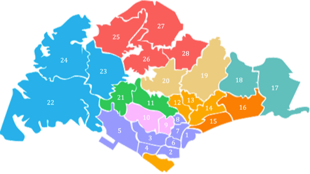
Singapore district map
This district map provides a broad visual reference. For a particular address, use its postal sector and the district table rather than estimating its district from the map.
What do Singapore’s 28 property districts mean?
District labels such as D09, D15 and D19 help describe property locations. Each district groups postal sectors and can cover several neighbourhoods. They provide a useful starting point for browsing listings and discussing locations, but they do not describe every feature of a property or its surroundings.
The general location names in the table are reference labels, not a complete list of streets or estates. Some neighbourhood names are used broadly and may span district boundaries. If you need a property’s district, start with its postal code.
Postal sectors, districts and URA market regions
- Postal code: the complete six-digit code used for an address.
- Postal sector: the first two digits of that code.
- Property district: one of the 28 districts shown in the reference table.
- URA planning area: a planning geography that should not be treated as interchangeable with a postal district.
- URA market segment: Core Central Region (CCR), Rest of Central Region (RCR) or Outside Central Region (OCR).
CCR includes postal districts 9, 10 and 11, plus the Downtown Core Planning Area and Sentosa. RCR covers the remaining Central Region, while OCR covers areas outside the Central Region. These definitions combine district and planning-area boundaries, so assigning every district wholesale to a market segment can be misleading. See the URA glossary and market-segment map.
Using district information when choosing a property
Use a district to narrow your search, then compare the actual property and its immediate surroundings. Two homes in the same district can differ substantially in accessibility, condition, tenure, noise and price.
Already shortlisted two homes in the same district? Use our same-district home comparison checklist to compare daily travel, layout, condition, price and ongoing costs.
- Daily travel: check realistic routes and journey times to work and places you regularly visit.
- Family needs: look at amenities and verify any school-distance or admission requirements for the specific address.
- Budget: compare relevant transactions, financing and total ownership costs rather than relying on a district’s reputation.
- Living environment: visit the street and development at different times to assess noise, traffic and practical comfort.
- Future plans: review applicable planning information and distinguish confirmed plans from assumptions.
A district label alone does not guarantee rental demand or capital appreciation. Your entry price, property characteristics, costs and market conditions matter. Our property buying considerations guide provides a broader checklist.
Frequently asked questions
Is my postal sector the same as my district number?
No. Sector 47, for example, belongs to District 16. Use the mapping table rather than treating the first two postal digits as the district number.
Can I enter a full postal code?
Yes. Enter exactly six digits and the finder will use the first two. It identifies the district from the reference mapping, without validating a specific address.
Can a neighbourhood span more than one property district?
Yes. Neighbourhood names can describe a wider area, and the general locations in the district table are only a guide. For a particular property, use the first two digits of its postal code in the finder above.
What if my postal sector is not recognised?
Check that you entered two or six digits correctly. The finder reports sectors absent from the reference rather than guessing a district. Confirm the address and consult the source reference if needed.
Reference and next steps
The district mapping follows the postal district list hosted by URA, credited to SingPost. District mapping and market-region definitions checked on 7 October 2026.
Explore our property tools and calculators to consider your budget and purchase payments. If you would like help comparing locations with your own priorities, contact Ming Property.